


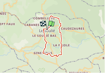
LE SOULIE

CANON2
User

Length
12.1 km

Max alt
957 m

Uphill gradient
281 m
Km-Effort
15.8 km

Min alt
855 m

Downhill gradient
277 m
Boucle
Yes
Creation date :
2022-06-15 06:47:27.576
Updated on :
2022-06-15 06:47:58.272
3h35
Difficulty : Easy

FREE GPS app for hiking
 SityTrail
IGN / Geographical institutes
SityTrail Plus
The world is yours!
About
Trail On foot of 12.1 km to be discovered at Occitania, Hérault, Le Soulié. This trail is proposed by CANON2.
Positioning
Country:
France
Region :
Occitania
Department/Province :
Hérault
Municipality :
Le Soulié
Location:
Unknown
Start:(Dec)
Start:(UTM)
474923 ; 4822080 (31T) N.
Comments